
This subproject is led by Prof. Dr. Michael Becht and apl. Prof. Dr. Tobias Heckmann at the Catholic University of Eichstätt-Ingolstadt. Our team consists of Dr. Sarah Betz-Nutz and Toni Himmelstoß (PhD student).
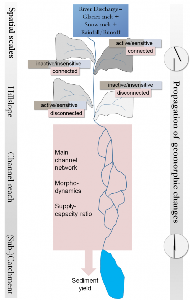
This subproject deals with the propagation of small-scale, local changes, for example increased sediment yield from hillslopes due to deglaciation: Will detached sediment reach the main channel, and will river discharge be strong enough to transport it further towards the catchment outlet ? Or will the sediment be stored in storage landforms, at the slope foot, or in the floodplains where the transport capacity of the river is not high enough ? What kind of changes can we observe in the main rivers between 1850 and today – are they incising, or are the floodplains aggrading ? The structure of the system could even change, through the formation of a new lake following ongoing glacier retreat.
Together with all subprojects, we aim at answering the question of how sensitively the study areas have reacted and are reacting to climate change. A combination of sensitive/active and well-coupled subareas would render the study area highly sensitive, while low activity and/or poor connectivity would indicate an insensitive system.
In the second phase of the research project, we will deploy landscape evolution models in order to achieve two goals. First, we need to go further back in time to reconstruct geomorphic processes in the main channel network mainly before the first official aerial photos (1950s). Second, we investigate how future climatic and consequential hydrologic changes might affect the morphodynamics and sediment transfer in the coming decades (until the year 2050). These models use digital elevation models and are driven by climate (SP1) and hydrological (SP2) model results.